
The Tongariro Crossing
Ruapehu District - Central Plateau - North Island of New Zealand
The Tongariro Crossing walking trek in New Zealand’s world heritage Tongariro National Park in the central North Island is one of the most scenic walks in New Zealand and is an absolute must do on any trip to New Zealand.
The Tongariro Crossing rates among the top five great walks - Milford Track, Routeburn Track, Kepler Track, Heaphy Track, and the Able Tasman Coastal Track and as being one of the finest walking tracks to be found anywhere in Australia and New Zealand and is consistently acclaimed as New Zealand’s best one day walk.
Mountain Weather – planning your walk
Weather on all three National Park mountains - Ruapehu, Ngauruhoe Tongariro can be extremely changeable. Alpine temperatures can range between 5 and 35 degrees in the summer, so basing yourself in Taupo accommodation such as Taupo Debretts Resort and waiting for the right day to do the crossing makes a lot of sense. Check the weather for the mountain with an experienced mountain operator such as Tongariro Expeditions before you leave. Essential tramping items for the walking trek, even in summer, include a rainproof coat, warm clothing, hat and gloves, good footwear (preferably trekking boots), sunglasses, sunblock, camera and film, extra food and minimum of 2 litres water.
Budgeting enough time for the Tongariro Trek
Although the Tongariro Crossing covers a distance of only 17 km (12 miles) one way, trekking across the alpine mountain landscapes and live volcanoes of the Tongariro National Park takes between 7-8 hours to walk comfortably at an even pace. Popular side tracks include climbing/scrambling up the mountain scree to the summit and crater of Mount Ngauruhoe (an additional 3 hours return), or turning off at Red Crater to reach the magnificent tableland of the Tongariro Summit (an additional 1.5 hours return) so if you intend to include either of these trekking options you will need to start bright and early.
Tongariro Walking Track - Start point and End point
The Tongariro Crossing starts and finishes at two different points, some 25 kilometres apart, so choosing a drop off and pick up mountain transport service such as Tongariro Expeditions is the most ideal way of walking the Tongariro track. Driving time to the National Park mountains from Taupo is approximately 45 minutes one way.
If you choose to be picked up from your Taupo Holiday Park Taupo Debretts, Tongariro Expeditions’ early bird service is recommended, as on a good summers day as many as 500 people are walking the track and this transport arrives up to 1 ½ hours before the large crowds get there, which means you are not walking the difficult climbs in the heat of the day.
Tongariro Expeditions’ can pick you up from Taupo Debretts Resort and will drop you back in time for a well earned relaxing soak at Taupo Hot Springs Spa’s hot mineral pools.
Tongariro – Lord of the Rings location
The volcanically active landscape around Mount Tongariro was used as one of the major settings for New Zealander Peter Jackson's film Lord of the Rings. Mt Ngauruhoe was used as Mt Doom or Orodruin, the mountain of fire in the Land of Mordor. Significant proportions of the J.R.R. Tolkien trilogy was filmed on location here in 1999 with the Tongariro National Park landscapes regularly featuring in parts of “The Fellowship of the Ring”, and its sequels “The Two Towers” and “The Return of the King”.
Tongariro National Park - History
New Zealand’s Tongariro National Park owes its existence to a forward-thinking Maori chief Te Heuheu Tukino IV (Horonuku) who ceded the land to the people of New Zealand on behalf of the Tuwharetoa tribe on the 23 September 1887 as a way to protect its sacredness from European settlers, farmers and loggers. Te heu Heu had heard about the creation of Yellowstone National park Originally 2,630 ha the park now covers 79,598 ha. or 196,687 acres, the national park is situated around a trio of active volcanoes: Tongariro, Ruapehu and Ngauruhoe. Mt Ruapehu, the highest point on the North Island, has erupted more than 60 times since 1945-including a spectacular 1995 eruption
Tongariro Crossing – Description of walk
The Tongariro Crossing across the mountain landscape of the Tongariro National Park takes between 7-8 hours to walk comfortably, treking a distance of 17 km (12 miles) one way.
The Tongariro trek begins at Mangatepopo Road in the west of the Tongariro National Park and ends at Ketetahi on the northern edge of the world heritage park.
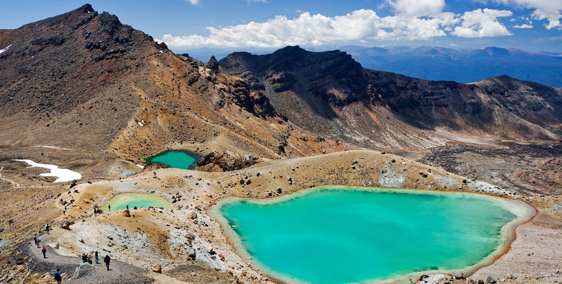
The Tongariro Crossing walk starts with a gentle gradient walk up from the Mangatepopo Valley then changes to a steep climb upto the Mangatepopo saddle between the active Volcanoes of Mt Tongariro and Mt Ngauruhoe, then a more gentle tramp across the South Crater and finally climbing up to Red Crater, the highest point (1886m) on the Tongariro Crossing track. Tongariro walkers then descend down to the Emerald Lakes (a group of water filled volcanic explosion craters), over the Central Crater to the Blue Lake (an old mountain vent) zig-zaging around Tongariro’s North Crater past the Department of Conservation’s Ketetahi Hut and the Ketetahi Hot Springs down through the native forest to the car park on State Highway 47A.
Tongariro Crossing times from the Mangatepopo car park to Soda Springs average approximately 1 hour, from Soda Springs to the South Crater about 45 minutes, from the South Crater to crossing’s high point at Red Crater about 1 hour, down from the Red Crater past the Emerald and Blue lakes to the Ketetahi Hut takes around 2 hours, then finally from the Ketetahi Hut, past the Ketetahi Springs to the Ketetahi car park takes a surprising 2 hours.
If you want enjoy other walking side tracks including climbing to the summit of Mt Ngauruhoe (3 hours), red crater to the tongariro summit 1.5hours sightseeing and lunch add another 2 hours to your day’s itinerary.